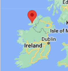
About G88
The landscape of G88 has been largely defined by the action of ice and water, and consequently contains a rich mosaic of habitats. To the north are the eastern reaches of the Blue Stacks mountain range, stretching from Binbane to Carnaween, the highest point in the square at 521m. Much of the remainder of the square forms a catchment for the abundant rainfall in these mountains. Numerous streams thread their way south and west, ending up in the Eany Beg Water which almost bisects the square. The Eany More brings yet more water from the Sruell and Eglish glacial valleys to the east, merging with the Eany Beg to form the Eany Water—a world class angling river that flows south into Inver Bay. Along these waterways are rich riverine habitats.
The Donegal Bay drumlin belt occupies the south of the square with its undulating landscape and varied mix of farmland, extensive hedgerows and wooded areas. There is some monoculture conifer plantation, but also a lot of deciduous woodland and scrub. The National Native Woodland Survey identified an area of oak-ash-hazel woodland adjoining the Eany Water in Cranny Upper.
The Meenaguse/Ardbane SAC extends into the north-eastern part of the square and contains good quality blanket bog. The extensive Lough Nillan Bog SPA wraps around the north-western flanks of the square, taking in Tamur Lough and Carnaween.
A number of small lakes are scattered throughout the square, the largest being Tamur Lough to the west. Upland loughs include Carn Lough in the shadow of Carnaween, and the tiny Miley’s Lough—pictured below, with Carnaween in the background.


Further information about G88 and surrounding area
Biodiversity information
Biodiversity Ireland - Dataset of records for G88 10km square
Downloaded 6 February 2024
Biodiversity Species List for Donegal (with priorities).
Published by Donegal County Council May 2009
Prepared by Gaia Associates

Lough Nillan Bog SPA
This NWPS managed SPA is on the edge of the selected bioblitz area

Bluestack
LCA 38 An Gaeltacht
Landscape character assessment for the Bluestack LCA published by Donegal County Council

Donegal Bay Drumlins
LCA 37
Landscape character assessment for the Donegal Bay Drumlins LCA published by Donegal County Council
Useful links and background information

Read - Tales from The Blue Stacks
Author - Robert Bernan
Stories and sketches are based on the author's experience living and working among a small group of farmers in the extreme northwest of Ireland whose lives continue to be rooted in the eighteenth century. First published January 1, 1978
[excerpt from Goodreads]
Robert Bernan lived and farmed on the very edge of G88. His writing is funny and socially informative and provides a window into a way of life that in some ways is radically altered, and in others is completely unchanged.

Learn - Disert Graveyard
Learn more about Disert Graveyard - a complex archaeological landscape located in the townland of Disert in Co Donegal. The site consists of a holy well dedicated to St Colmcille surrounded by a ritual pilgrim landscape that includes an early ecclesiastical enclosure, penitential cairns and a cillin (children’s graveyard).

Walk - The Bluestack Way
The Bluestack Way is a 65km route through a true wilderness area of County Donegal in the north west of Ireland with great views as it traverses the Bluestack Mountains. It connects Donegal town with the town of Ardara on the west coast. Along the way the route passes by scenic Lough Eske, and then wends its way across the foothills of the Bluestacks to reach an area called Disert, where there is an ancient mountain graveyard. West of Disert the route goes over rough and remote high moorland terrain between Binbane and Cloghmeen Hill before descending along the Owenroe river to reach a bog road.
© 2024


